Five Years on the Cliff
This gallery contains 2 photos.
The 2014 field season marks the 5th year of the Cliff Mine Archaeology Project. The anniversary provides an opportunity for a brief assessment of what we’ve accomplished in our studies of this significant historical site, as I start to post the field team’s new blog posts about the current work. The project began during the […]
The blog is back. Happy 2014!
Welcome back to the Cliff Mine Archaeology Project blog. I started this blog back in the spring of 2010 to follow research that formed the heart of my Master’s thesis. I continued working at Cliff for the next two summers, focusing on excavations at the mine’s stamp mill location. In 2012, additional student researchers joined […]
Field School Week 2: Mapping and Context
Students learn mapping as their first major field research skill. We begin with mapping because this is the first skill from which all other archaeological tools derive: the ability to know where something is in relation to other things. An archaeologist must be able to control their data collection, locating things in space and time on the landscape. You can think of this in one way as the X, Y, and Z coordinates where a thing was found. We call that information an artifacts provenience, and because we know how things relate to each other in space (and thus time), we can say things like “These two artifacts were buried at the same time, roughly 1855” or “That button was manufactured in 1863 and it was in a layer of sediment deposited when this foundation was laid, so this building was built sometime in or after that year.” If someone brings me a button or bottle that they have removed from a site, they have lost most of this information and that greatly reduces the information we can learn about daily life at the site through that object.
So knowing where things are is key. Building from that, an archaeologist needs to be able to put things they see on or in the ground into the absolute space of maps, using systems like UTM, Township and Range, or Latitude and Longitude. These skills matter because it takes a great deal of work to be able to look at a foundation on the ground today and definitively say, this is the foundation of this structure indicated on this 1849 map. Figuring that out can be very hard. Just ask Sean and the other research team members.
The students eventually learn to work with an EDM/Total Station, GPS, and sometimes other technologies like LiDAR. When we teach mapping, however, we really start with basics because we want the students to understand the processes behind the button pushing for digital data. The students start learning basics: the significance of triangles and trigonometry; triangulation by measurements, triangulation by bearing, and bearing-and-distance mapping; determining scales; and drawing by hand.
We spent time during the first and second weeks making maps of campus buildings. One team stretched tape measures to build a triangle of three base points, then measured distances from those points to all the key building corners. The second team used magnetic compasses to take bearing readings off magnetic north from a single point, then measure the distance. Then both teams plotted their buildings onto hand-drawn maps at the same scale. This was the result:
Not bad for a first try!

This is an optical transit, similar to the model used by Michigan Tech Industrial Archaeology students when they learn the basics of surveying and map making. Creative Commons image courtesy of Land Surveying Services, Inc.
Later, when we went into the field to the South Cliff Stamp Mill, we pulled tape measures to lay in base points and started making our map of the building remains. We also started learning how to use an optical transit. This is pretty easy to learn until you depress or incline the angle of your telescope, so I’ll spare you all the math. Using the optical equipment certainly prepared the students to appreciate the EDM and GPS units!

This schematic diagram shows computations of distance using stadia measures, when the transit is level. Creative Commons image courtesy of the Food and Agriculture Organization of the United Nations.

Kaeleigh, Jordan, Rob, and Connor plot points on a scaled map of the South Cliff Stamp Mill. And yes, that is snow on the ground at the end of May in the Keweenaw.

Tim Goddard teaching Connor Will how to use the Total Station/EDM to collect geospatial data.
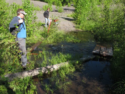
As the work progressed, the students generated a scaled drawing of the mill’s main features in the field. Working from this drawing, they were able to then select areas for shovel test pits. We wanted to assess the potential of the South Cliff Stamp Mill for archaeological excavation.
The third week, Tim Goddard was able to spend some time with us in the field, teaching about the EDM/Total Station as a tool for collecting geospatial data. The students learned quickly and they reshot many of the South Cliff points again, so we will be able to compare the digital with our “analog” data. The EDM data will allow us to easily add the new information about the South Cliff Stamp Mill into the CliffMAP GIS.

Kaeleigh Herstad levels the prism to record machine anchor bolts in the South Cliff Stamp Mill.
We were generally pleased with the results and look forward to showing our open house visitors the stamp mill site and explaining what we have learned about it during the week we spent studying it. We’ve only had a quick and preliminary view, but it looks very promising for more research. This mill also has an interesting story as a place of technological experimentation and it gave us tantalizing clues!
Field School Week 1: Geology and Snow in the Woods!
The first week of the field school is dedicated to orientations and background knowledge. The students come to fieldwork with different backgrounds and experiences, which makes for a great learning environment as they develop into a team collaborators and colleagues. We start intensive training and build from the ground up, and so we begin with geology!
Geology is important to understanding what has drawn humans to the Keweenaw for millennia. Many readers of the blog already know a great deal about the geological formation of the Keweenaw and Lake Superior Basin. For those who don’t, you’ll be happy to learn that the communities have made steady improvements in our heritage.
In past years, we’ve enjoyed an introduction to Keweenaw geology from Dr. Bill Rose of Michigan Tech’s Geological & Mining Engineering & Sciences Department. This year we tried an experiment using the online educational resources that Dr. Rose, his students, and collaborators have published. From the very beginning, we started challenging the students to think about how they can effectively tell stories from their work at the Cliff Mine and in Clifton. Dr. Rose has worked hard to keep his scientific studies grounded in public science. As a result, the work that he and his colleagues do has been a great comparative study for our research team. In this case, they can learn from online resources (under our guidance), while also learning the costs/benefits of online presentations of cultural and natural heritage. The “geopark” concept is a great case study. These heritage parks combine both “natural” and “cultural” heritage into a single system, while many other management organizations around the world stubbornly keep people and nature separate from each other.
We started the students with this recorded lecture in which Bill explains the history of the Keweenaw Rift and the formation of the Lake Superior Basin:
http://www.geo.mtu.edu/~raman/KewFall091.1.mov
Then we jumped in our van and took the students to look at geology in the field. We used a couple of resources where we could show the students rocks and landforms in both “zoos” and in their “natural habitat.”
To see rocks and minerals in zoos, we started at Michigan Tech’s new Boulder Garden:
http://www.geo.mtu.edu/~raman/SilverI/Boulder_Garden/Welcome.html
We are saving the next resource for a rain day later in the field season, but we plan to visit more geological specimens in the newly remodeled A. E. Seaman Mineral Museum at Michigan Tech. The Seaman is Michigan’s Official State Mineral Museum.

Silver crystals (to 0.6 cm) on copper.
Wolverine Mine, Keweenaw County, Michigan
A. E. Seaman Mineral Museum, Michigan Technological University
John T. Reeder collection #431.
John A. Jaszczak photo.
From the “geology zoos” we move on to learn geology the best way, by looking at landscapes in the field. This included two major driving trips. We loaded into the van and headed on a trip around the Keweenaw, from Houghton and Hancock and the Quincy Overlook to Calumet and along the spine of the peninsula via Cliff Drive; to the north shore via Eagle River, Eagle Harbor, and Copper Harbor; back up onto the spine to Brockway Mountain and then down to Lac La Belle; back along the south shore to Gay, and Torch lake and home. The next trip was a day long hike into the Porcupine Mountains State Park to study the geology, landforms, and mining sites in parts of the park. The trips were challenging this year because of the heavy and late snow. Snow still covered some of the landscapes and the high spring flood waters also obscured some of the geological features we hoped to see. Not all the roads had been throughly cleared of snowmobile traction studs yet, a perennial problem in Michigan’s UP early in spring.

Professor Sam Sweitz changes a flat tire on our field trip van in Ontonagon, Michigan.
We also used a couple of online resources for these trips:
The new Houghton Geology Walk/Bike Site System:
http://www.geo.mtu.edu/~raman/SilverI/HoughtonEC/Welcome.html
We also drew upon the resources established for the Michigan Teacher Excellence Program (MITEP), using these pages:
http://www.geo.mtu.edu/~raman/SilverI/MiTEP_ESI-1/Welcome.html
http://www.geo.mtu.edu/~raman/SilverI/MiTEP_ESI-2/Welcome.html
The first week also covered introductions to mining technology and history, the antiquity and history of the Keweenaw, and other material (like basic first aid and wilderness emergency response). More information soon!
Fieldwork is underway!
This gallery contains 1 photo.
I’m dreadfully far behind in my updates to the Cliff Archaeology Blog! The field school research teams are in their fourth week of work. We are almost ready for the open houses which start next weekend (June 15-16) and continue each weekend through the end of June (22-23 & 29-30). We finished a quick study […]
Stakeholder Meeting for Eagle River Remediation/Cliff Mine Site.
Today I received an email from Gina Nicholas, of the Houghton Keweenaw Conservation District. Next week, the HKCD is going to hold a meeting for representatives of different stakeholder groups with interest in the Cliff Mine site and the remediation of stamp sands from historic sites along the Eagle River. During the meeting, Chad Kotke will present an update of the DEQ remediation plan. After this meeting, the Conservation District holds their public meeting, during which Mr. Kotke will give a lecture about the project.
If you have an interest in the Cliff or Clifton, consider contacting a representative of one of these organizations to discuss your views. Of course, the public is always invited to join the Conservation District.

Dear Cliff Mine Stakeholders,
A meeting with Chad Kotke, DEQ, is scheduled for Thursday, March 21 from 2:00-3:30 PM at the MTU Lakeshore Center, first floor board room, to discuss plans for Cliff and restoration of the Eagle River. You and your organization have been identified as key stakeholders and we hope you or a designee(s) will attend.
Organizations invited include:Keweenaw County Road Commission (KCRC)Keweenaw County Historical Society (KCHS)Keweenaw National Historical Park (KNHP)Keweenaw Bay Indian Community (KBIC)Michigan Tech — Industrial Archaeology ProgramNatural Resources Conservation Service (NRCS)Houghton Keweenaw Conservation District (HKCD)Michigan Department of Environmental Quality (DEQ)
If you think there are other key stakeholders please call me.Attached for your use is a map of the Cliff site.Please call me if you have any questions about this meeting.We look forward to seeing you on March 21!

Check Out a Fellow Blogger’s Post on his recetn Visit to the Cliff.
Early in the field season I was contacted via email by Frank Hutton, a photographer and artist interested in the Lake Superior basin’s cultural and natural wonders. Frank has a blog running, “In Search of Perfect Light…,” and asked me if he could visit our workings and maybe write up a post on his visit. […]
The Rain Really Needs to Stop
This gallery contains 3 photos.
I understand how badly the Upper Peninsula needs rain right now but the last two days have seen too much of it. Just getting to the site requires wading through water. It should go down enough that by the weekend visitors will be able to come out without worry of getting wet (and I DO […]
Thanks For Your Help
As we are about to start our open house weekends, I wanted to take a moment to offer thanks to a few key organizations that have helped us bring the Cliff Mine Archaeology Project to fruition over the years.
First and foremost, I must thank our host, the Keweenaw County Road Commission. The KCRC owns the Cliff Mine site. The county purchased the property years ago with the idea that they would use the poor rock piles as gravel on road projects. They hold the land as an investment for the tax payers of Keweenaw County. The Road Commission have been tremendously supportive through permission to do this archaeology study for three consecutive years. They give us permission to map, dig, and remove items from the site for scientific and historical study. In addition, they have made very wise decisions about site management, and I know that all the members of our collaborative research team- faculty, graduate and undergraduate students, and volunteers (spread over three years so far), are all grateful for the commission’s support.
Next, I’d like to thank our sponsors. None of our study would be possible without the support of several key organizations and individuals. Doing archaeology costs real money. Pure historical research, where a scholar works in an archive or county records room, costs much less. One scholar can decide to spend three weeks of the summer in an archive, with only concern for travel costs. By contrast, archaeology requires a team of workers. The artifacts and ecofacts that we recover are fundamentally different from the notebook filled with data by that “lone wolf” historian. The hundreds or thousands of objects need to be washed, cataloged, conserved, and archived. A report of the dig must be written, that lays down all the technical details for posterity. These are the things that separate professional archaeologists from for-profit salvage operators or pot hunters. The analysis and reports, done correctly, require real money to pay for scientific analysis, mundane field equipment and supplies, and student labor in the lab after the dig ends.
Our budget generally breaks down into three parts, and I with to thank each in turn:
1. The Department of Social Sciences at Michigan Technological University lends us valuable technical equipment for the project and spends real dollars to support to undergraduate and graduate students, provide vehicles and fuel, and administrative support.
2. The Keweenaw National Historical Park Advisory Commission, through their Heritage Grants program, helps to support graduate students during analysis and report preparation.
3. Private gifts from individuals and corporate sponsors are essential to our successes, as they make up a third or more of our annual budget. These gifts help us provide support for students (such as Sean Gohman, our excellent blog author and public speaker), cover the costs of scientific analyses, permit us to purchase supplies like nails, string, and shovels. In particular, I am pleased to thank Joe and Vickey Dancy, LSGI Technology Venture Fund L.P., Bill and Eloise Haller, and Paul LaVanway.
If you have enjoyed Sean’s blog or you’ve been able to come out to see one of our open houses, please consider making a gift of support to the Michigan Tech Fund account for the Cliff Mine Archaeology Project. Gifts of all sizes are helpful and appreciated!
Finally, I would also like to thank some of our intellectual partners in this heritage endeavor! We are grateful for the support of many people during our research. Everyone on the research team has benefited from our interactions with three institutions in particular:
1. The staff of the Michigan Tech Archive and Copper County Historical Collections at Michigan Technological University has been a tremendous research resource. Besides being one of the key repositories for primary historic documents and photographs, the staff have also been excellent colleagues. The CCHC has given us permission to use their images on this blog and in our public archaeology efforts at the site. We are very grateful.
2. The Keweenaw County Historical Society, and its community of scholars, have been very supportive of our work at Cliff. Their members have shared their research with us and continue to collaborate with us on many research topics regarding Cliff, Clifton, and the connections to Eagle River. We strongly advise everyone to visit their museums in Eagle River, Central, and other places. Everyone should go to see their brand new exhibit on Cliff and early Keweenaw County life when it opens this summer!
3. Our colleagues at the Keweenaw National Historical Park have been very enthusiastic about our work. One thing we learned during last year’s open house tours is that it really makes a difference when a staff member at one of the Park’s heritage sites advises visitors to go see the archaeologists while they are in the field. Those human interactions make a big difference in the way guests experience the heritage of the Keweenaw. We are thankful to have National Park staff as colleagues in our efforts to research and teach about the heritage of this region.
That’s enough for now! We’ll have a big day tomorrow and I need to get some sleep before the tours start!
Tours Start Tomorrow
This gallery contains 1 photo.
Sorry for the lapse in posting but we are working like mad trying to prepare for the public open house tours that start tomorrow at Cliff. Come on out and see what we’ve been up to. Then come again the following weekends to see how it all ends.

Recent Comments